Arizona
https://www.facebook.com/watch?v=1218249012096045
Peter Santenello
·
Following
December 18, 2022 ·
Life on Biggest Indian Reservation in America 🇺🇸
Peter Santenello
·
Following
December 18, 2022 ·
Life on Biggest Indian Reservation in America 🇺🇸
Table of Contents
Each topical entry carries byline, timeline, location, and references to leaders.
Each topical entry carries byline, timeline, location, and references to leaders.
|
Maps
Archaeology, Paleontology and Anthropology Astronomy and Ancient American Bicycling Cosmology Decolonize
|
(cont.)
First Nations Geology Music, Art, and Dance The Spell of the Sensuous
|
(cont)
Research Concepts and Resources
TSLGBTQ+ Alphabetical Region Directory & Maps Photographs RoadTrip Itinerary Maps (continued) Resources Getting Naked in Arizona |
Maps
Roadtrippers Map version 11/13/2022

Apacheria


First Nations


Native American Reservations


Federally Recognized Tribes in Arizona
Federally Recognized Tribes in Arizona

The map shows the land of Anasazi. The Ancient Pueblo were one of four major prehistoric traditions recognized in the southwestern North America.
List of Ancestral Pueblo Dwellings in Arizona
List of Ancestral Pueblo Dwellings in Arizona
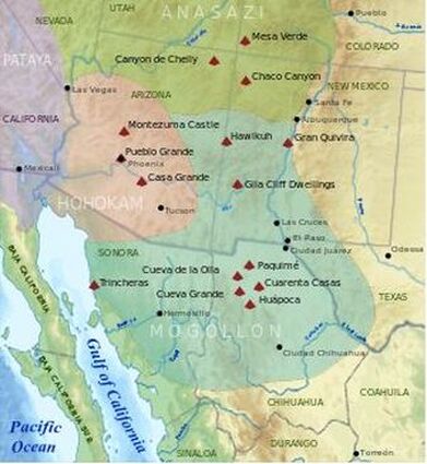
Anasazi - Navajo word meaning “ancestors of the enemy." AD 100 to 1600. Ancestral Pueblo prehistory is typically divided into six developmental periods. The periods and their approximate dates are Late Basketmaker II (AD 100–500), Basketmaker III (500–750), Pueblo I (750–950), Pueblo II (950–1150), Pueblo III (1150–1300), and Pueblo IV (1300–1600). When the first cultural time lines of the American Southwest were created in the early 20th century, scientists included a Basketmaker I stage. They created this hypothetical period in anticipation of finding evidence for the earliest stages of the transition from hunting and gathering economies to fully agricultural societies. By the late 20th century archaeologists had concluded that Basketmaker II peoples had actually filled that role. Rather than renaming Basketmaker II and III to reflect this understanding of the evidence, Basketmaker I was generally eliminated from regional time lines, although some scientific discussions about its role in regional chronologies continued in the early 21st century.
Chronologies
The Timeline of Native Americans - The Ultimate Guide to North America's Indigenous Peoples, Greg O'Brien. Thunder Bay Press, San Diego. 2008.
Water is Life
Aquifers

1. Basin and Range Basin-fill Aquifer (light blue)
2. Rio Grande Aquifer System (sky blue)
23. CO Plateau Aquifers (green)
43. Roswell Basin Aquifer System (brown)
2. Rio Grande Aquifer System (sky blue)
23. CO Plateau Aquifers (green)
43. Roswell Basin Aquifer System (brown)
Arizona Watersheds

Arizona Watersheds ASU
Arizona drains entirely into the Colorado River, and the numerous watersheds within the state are all connected. All about at Youtube
Upper Colorado River Basin
Arizona drains entirely into the Colorado River, and the numerous watersheds within the state are all connected. All about at Youtube
Upper Colorado River Basin
First Flow: The Santa Cruz River at Wa:k TUCSON This video shows the "first flow" of the Santa Cruz River in decades in the channel near San Xavier del Wa:k. The video was prepared in fall of 2018 about 6 months after the first evidence of a new perennial flow was identified. Drone footage and comments by Wa:k O'odham community members provide a sense of the importance of the revival of river flow here. Historically, the river used to flow on the surface perennially in this area (until the river was essentially killed as a result of groundwater pumping, channel modification, and wood cutting, after which the river would only flow after up-stream rains). Surface flow was facilitated by the near surface bedrock that pushed the flow to the surface. The spring was to the south/upstream from the community. The flow formed an expansive marsh south of Martinez Hill, where this flow began, and then it flowed as a stream to the north or downstream from that hill where the Sobaipuri used its flow for irrigation agriculture. They had fields and canals so extensive that Kino and his religious companions were impressed. Reasons for the new flow are provided.
Archaeology, Paleontology, and Anthropology
The Western Archeological and Conservation Center (WACC) is dedicated to the preservation and study of museum collections within the Intermountain Region of the National Park Service. The Museum Services Program at WACC provides expertise in professional conservation, museum, archival, and library management assistance to park staff and partners. Staff here curates 14.5 million objects and archives on behalf of over 70 parks, preserving this valuable part of America's heritage and making it accessible for research. Artifacts from Organ Pipe Cactus National Monument are housed here.
Crow Canyon Archaeological Center Crow Canyon’s mission is to empower present and future generations by making the human past accessible and relevant through archaeological research, experiential education, and American Indian knowledge.
The Crow Canyon Archaeological Center acknowledges the Pueblo, Ute, Diné (Navajo), Jicarilla Apache, and Paiute people on whose traditional homelands we work and reside.
Astronomy and Ancient American Cosmology
Phases of the Moon
ASU Planetarium
Chaco Astronomy - An Ancient American Cosmology, by Anna Sofer and Contributors to The Solstice Project
The Solstice Project studies the rich astronomical heritage of the ancient Chaco culture in the American Southwest. Founded in 1978 by Anna Sofaer, our non-profit organization publishes research and produces award-winning films that document the Chaco culture’s scientific achievements.
The Mystery of Chaco Canyon - Amazon Prime Video
www.amazon.com/Mystery-Chaco-Canyon-Robert-Redford/dp/B08VFBPXC3/ref=sr_1_1?crid=3NQESB3BJPU4R&keywords=the+mystery+of+chaco+canyon+robert+redford&qid=1642871543&s=instant-video&sprefix=The+Mystery+of+Chaco+Canyon%2Cinstant-video%2C156&sr=1-1
The Sun Dagger on Fajada Butte in Chaco Canyon (NCAR/UCAR High Altitude Observatory)
Rent The Sun Dagger Video at Vimeo
Clear Sky Chart light pollution map.
The Spell of the Sensuous: Perception and Language in a More-Than-Human World and Becoming Animal: An Earthly Cosmology, by David Abram
Arizona Dark Skies
|
Decolonize
|

|
Native Hope Native Hope exists to address the injustice done to Native Americans. We share Native stories, provide educational resources, and assist Native communities.
- Food and Medicine Sovereignty
- Indigenous Issues & Journalism
- Indigenous Rights of Nature (IRON)
As Long As Grass Grows, by Dina Gilio-Whitaker "Indigenized environmental justice"
- Native American Languages and Education
Geology
Great Basin and Southwest Deserts

Music, Art, and Dance
When the Rainbow Touches Down, by Tryntje Van Ness Seymour - Apache, Navajo, Rio Grande Pueblo, Hopi
American Indian Design and Decoration, by Leroy H. Appleton
Pueblo Crafts (New Mexico), by Ruth Underhill PhD.
Arizona Powwows
Annual Quechan Pow Wow March, 4th-6th. Winterhaven, CA. Fort Yuma Quechan Tribe Website.
Wa:k Powow March 5-6. Annual gathering of Tucson's Tohono O'odham Indian Tribe and other tribes, with dancing, drumming, craftworks, and food. Mission San Xavier del Bac. Facebook First Flow: The Santa Cruz River at Wa:k
Heard Museum Phoenix
The Story Tellers, Warriors, and Leaders
Tell Me a Story: Genomics vs. Indigenous Origin Narratives Indigenous critics worry--for good reason--that an insidious sort of racism persists in some genomic research, especially when its sights are set on Indigenous peoples and their origins Kim TallBear
The Gift of Changing Woman, by Tryntje Van Ness Seymour Ndee (in-deh) The People Apache
| the_gift_of_changing_woman.pdf |

|

|

|
When the Rainbow Touches Down, by Tryntje Van Ness Seymour Ndee (in-deh) The People (Apache), Diné (Navajo), Rio Grande Pueblo, Hopi

|

|
All Roads Are Good - Native Voices on Life and Culture National Museum of the American Indian
I studied under Grandpa Fools Crow,
a Lakota holy man. He said never
bad mouth anybody, never be envious or jealous
of anybody; if you are, you won't
be on the right road youself,
'cause all roads are good.
- ABE CONKLIN
- from All Roads Are Good - Native Voices on Life and Culture
a Lakota holy man. He said never
bad mouth anybody, never be envious or jealous
of anybody; if you are, you won't
be on the right road youself,
'cause all roads are good.
- ABE CONKLIN
- from All Roads Are Good - Native Voices on Life and Culture
Diné Bahaneʼ - The Navajo Creation Story, by Paul G. Zolbrod
"This is the most complete version of the Navajo creation story to appear in English since Washington Matthews' Navajo Legends of 1847. Zolbrod's new translation renders the power and delicacy of the oral storytelling performance on the page through a poetic idiom appropriate to the Navajo oral tradition. Zolbrod's book offers the general reader a vivid introduction to Navajo culture. For students of literature this book proposes a new way of looking at our literary heritage."
"This is the most complete version of the Navajo creation story to appear in English since Washington Matthews' Navajo Legends of 1847. Zolbrod's new translation renders the power and delicacy of the oral storytelling performance on the page through a poetic idiom appropriate to the Navajo oral tradition. Zolbrod's book offers the general reader a vivid introduction to Navajo culture. For students of literature this book proposes a new way of looking at our literary heritage."
Coyote Stories, by Mourning Dove (Humishuma)
Reinventing the Enemy's Language - Contemporary Woman's Writings of North America, edited by Joy Harjo and Gloria Bird
When the Light of the World Was Subdued, Our Songs Came Through - A Norton Anthology Native Nations Poetry Edited by Joy Harjo with Leanne Howe, Jennifer Elise Foerster, and Contributing Editors.
Iktomi the Trickster
| iktomi-the-trickster.pdf |
Research Concepts and Resources
Facebooks
Facebooks
Weather, Climate, and Navigation
TSLGBTQ+
| eco-queermovements.pdf |

|
The Milky Way sets over Lomaki Pueblo at Wupatki National Monument, with the glow of Flagstaff in the
distance. |
Astronomy and Ancient American Cosmology
Phases of the Moon
ASU Planetarium
Chaco Astronomy - An Ancient American Cosmology, by Anna Sofer and Contributors to The Solstice Project
The Solstice Project studies the rich astronomical heritage of the ancient Chaco culture in the American Southwest. Founded in 1978 by Anna Sofaer, our non-profit organization publishes research and produces award-winning films that document the Chaco culture’s scientific achievements.
The Mystery of Chaco Canyon - Amazon Prime Video
www.amazon.com/Mystery-Chaco-Canyon-Robert-Redford/dp/B08VFBPXC3/ref=sr_1_1?crid=3NQESB3BJPU4R&keywords=the+mystery+of+chaco+canyon+robert+redford&qid=1642871543&s=instant-video&sprefix=The+Mystery+of+Chaco+Canyon%2Cinstant-video%2C156&sr=1-1
The Sun Dagger on Fajada Butte in Chaco Canyon (NCAR/UCAR High Altitude Observatory)
Rent The Sun Dagger Video at Vimeo
Clear Sky Chart light pollution map.
The Spell of the Sensuous: Perception and Language in a More-Than-Human World and Becoming Animal: An Earthly Cosmology, by David Abram
Arizona Dark Skies
Phases of the Moon
ASU Planetarium
Chaco Astronomy - An Ancient American Cosmology, by Anna Sofer and Contributors to The Solstice Project
The Solstice Project studies the rich astronomical heritage of the ancient Chaco culture in the American Southwest. Founded in 1978 by Anna Sofaer, our non-profit organization publishes research and produces award-winning films that document the Chaco culture’s scientific achievements.
The Mystery of Chaco Canyon - Amazon Prime Video
www.amazon.com/Mystery-Chaco-Canyon-Robert-Redford/dp/B08VFBPXC3/ref=sr_1_1?crid=3NQESB3BJPU4R&keywords=the+mystery+of+chaco+canyon+robert+redford&qid=1642871543&s=instant-video&sprefix=The+Mystery+of+Chaco+Canyon%2Cinstant-video%2C156&sr=1-1
The Sun Dagger on Fajada Butte in Chaco Canyon (NCAR/UCAR High Altitude Observatory)
Rent The Sun Dagger Video at Vimeo
Clear Sky Chart light pollution map.
The Spell of the Sensuous: Perception and Language in a More-Than-Human World and Becoming Animal: An Earthly Cosmology, by David Abram
Arizona Dark Skies
As Long As Grass Grows, by Dina Gilio-Whitaker "Indigenized environmental justice"
Birds
Cranes - Wildwater Draw Wildlife Area near McNeal, AZ (other birds to look for here are listed)
More than 40,362 Sandhill Cranes make their way to Southern Arizona Jan. 12, 2022
The largest concentration of 25,734 is at AZGFD’s Whitewater Draw Wildlife Area near McNeal. The Willcox Playa area has 17,938 cranes; the Safford Valley/Duncan, 2,324; Rodeo/Portal; 820; Bonita, 585.
More than 40,362 Sandhill Cranes make their way to Southern Arizona Jan. 12, 2022
The largest concentration of 25,734 is at AZGFD’s Whitewater Draw Wildlife Area near McNeal. The Willcox Playa area has 17,938 cranes; the Safford Valley/Duncan, 2,324; Rodeo/Portal; 820; Bonita, 585.
Arizona Birds Arizona State Parks and Trails
A Pocket Naturalist's Guide to Southwest Desert Birds, Kavanaugh & Leung Waterford Press
The Buffalo
Reptiles
Plants and Animals
A Pocket Naturalist's Guide to Southwest Desert Life, Kavanaugh & Leung Waterford Press
A Pocket Naturalist's Guide to Southwest Desert Plants, Kavanaugh & Leung Waterford Press
|
The Trees
|

Underground root system of a white pine via Miroslava Marinova
|
Leaf of Life Biodiversity, Native Pollinators, Ecosystem Restoration & Permaculture, memes and info about sustainability, local foods, native plants, reversing climate change and poverty solutions.
2 Sacred Medicine Trees of North America, by Nick Polizzi January 27, 2022
Wolves
Geology
Roadside Geology of Arizona, by Halka Chronic
While the actual rocks of the Phoenix Mountains (including the areas around Piestewa Peak and North Mountain) are very old, the mountain shapes are, geologically speaking, quite young. They were formed about 14 million years ago as the crust of the earth was gradually stretched from northeast to southwest, elevating mountain ranges and down dropping the basins between them. Much of the area’s rock is a metamorphic type of granite known as schist. Mercury mines were worked in the area of today’s Dreamy Draw Recreation Area.
Archaeology
First Flow: The Santa Cruz River at Wa:k TUSCON This video shows the "first flow" of the Santa Cruz River in decades in the channel near San Xavier del Wa:k. The video was prepared in fall of 2018 about 6 months after the first evidence of a new perennial flow was identified. Drone footage and comments by Wa:k O'odham community members provide a sense of the importance of the revival of river flow here. Historically, the river used to flow on the surface perennially in this area (until the river was essentially killed as a result of groundwater pumping, channel modification, and wood cutting, after which the river would only flow after up-stream rains). Surface flow was facilitated by the near surface bedrock that pushed the flow to the surface. The spring was to the south/upstream from the community. The flow formed an expansive marsh south of Martinez Hill, where this flow began, and then it flowed as a stream to the north or downstream from that hill where the Sobaipuri used its flow for irrigation agriculture. They had fields and canals so extensive that Kino and his religious companions were impressed. Reasons for the new flow are provided.
SAN XAVIER DEL BAC MISSION - Tohono O'odom Nation TUCSON, AZ The O'odham were seasonal farmers who took advantage of the rains. They grew crops such as sweet Indian corn, beans (tapery), squash, lentils and melons. They also took advantage of native plants, such as saguaro fruits, mesquite tree beans, cholla buds and mesquite candy (sap from the mesquite tree). At present very few O'odham farm due to lack of pumping of underground water. Today many O'odham work for the Tohono O'odham Nation or federal government. Others are ranchers, and many who live close to the Nation's boundaries work in the metropolitan cities of Phoenix, Casa Grande and Tucson.Shared History of the Upper Gila River Watershed University of Arizona
Created by the University of Arizona Water Resources Research Center for the Gila Watershed Partnership.This timeline was created by the University of Arizona Water Resources Research Center from stories and events collected April 10, 2013 at a meeting of the Gila Watershed Partnership. It reflects the collective memory of local citizens and is not intended to represent a comprehensive or perfect history of the region.
Upper Gila River Watershed The Gila River originates in the Mongollon Mountains of New Mexico and flows West across Arizona to join the Colorado River at the California border near Yuma. ... According to the Arizona Water Resources Development Commission (WRDC), the Upper Gila Watershed will have unmet water demands by 2035.
Insects
Food and Health Sovereignty
- Native American Foods, Food Plants and Herbs
Continuing to Honor Our Food Traditions - Indian Country Today
Western Edible Wild Plants, by H.D. Harrington and Y. Matsumura (illus.)
Edible Native Plants of the Rocky Mountains, by H.D. Harrington and Y. Matsumura (illus.)
Wild Foods - A beginner's Guide to Identifying, harvesting and cooking safe and tasty plants from the Outdoors, by aurance Pringle and Paul Breeden (illus.)
The Sioux Chef's Indigenous Kitchen, by Sean Sherman with Beth Dooley
Pueblo Indian Cookbook - Over 130 Authentic Kitchen Tested Recipes, text drawings by Phyllis Hughes (Santa Fe, New Mexico). Museum of New Mexico Press. Larry Littlebird - Santo Domingo Laguna. BRINGING BACK THE SACRED IN THE WAY WE EAT, GROW AND SHARE OUR FOOD. Priscila Vigil - Teseque Pueblo, New Mexico.
the people
The quiet, subtle laughter of women
as they prepare the meal.
The food, hot and steaming, nourishing,
served in a pottery bowl; the same color as the people.
The flow of the awakening sun as it pours itself
into the darkness of mud-plastered walls beginning another day.
This is the world of the Pueblo.
And now this is the new day.
The laughter is still subtle, still quiet.
The food is still hot, still humbly accepted and given thanks for.
Only the plaster has changed,
but the sun is still round, like the pottery,
like the kiva, and still the color of the people.
- LARRY LITTLEBIRD Santo Domingo-Laguna
Sonoran Desert Food Plants - Edible Uses of the Desert's Wild Bounty, by Charles W Kane
Southwest Medicinal Plants: Identify, Harvest, and Use 112 Wild Herbs for Health and Wellness, by John Slattery
Native American Herbalists's Bible - Anceint Tradiditons and Practices, by Cheyenne Allen
Survival Life - for Preppers

The Healing Power Of Pine Medicine (DIY Recipes!), by Nick Polizzi December 2021
Botany
Kumeyaay Ethnobotony - Shared Heritage of the Californias, by Michael Wilken-Robertson
UNLV Arboretum NV
Tucson Botanical Garden Sonoran Desert AZ
Desert Botanical Garden - Sonoran Desert - Phoenix, AZ
History of the Upper Gila River Watershed
| 2_history_ugrw_atlas_web.pdf |
Canyon Country Prehistoric Rock Art, by F.A. Barnes CCPRA
Prehistoic Indians of the Southwest, by H.M. Wormington Denver Museum of Natural History
Prehistoric Rock Art, by F.A. Barnes
Native Languages and Education

As Long As Grass Grows, by Dina Gilio-Whitaker "Indigenized environmental justice"
Earth-Based Spirituality
|
Navajo Night Chant
|
| ||
Alphabetical Directory & Maps
Get Naked in Arizona
Intertribal Council of Arizona Maps &c.
Recreation.gov accomodations
List of Ancestral Pueblo Dwellings in Arizona
Native America - Amazon Prime Video
At the intersection of Native knowledge and modern scholarship is a new vision of America and its people.
https://www.amazon.com/New-World-Rising/dp/B07MTWZL8M/ref=sr_1_1?crid=1ID56LJOB1D1M&keywords=native+america&qid=1642871802&s=instant-video&sprefix=native+america%2Cinstant-video%2C216&sr=1-1
Ak-Chin Indian Community 35 miles south of Phoenix. Ak-Chin Him Dak Eco-Museum is a first-of-its-kind living museum that includes and preserves our culture, land and heritage. “Our language is our medicine. We lose our language, we lose our medicine” -Gabriel Lopez The Native American language for Ak-Chin Indian Community is O’odham. Ak-Chin is an O’odham word meaning “mouth of the wash.” As of April 2019, the Ak-Chin Indian Community is the first to have state-certified O’odham language teachers.
Anza-Borrego National Park CA
Bears Ears, Cedar Mesa, Valley of the Gods
Bears Ears Intertribal Coalition In July of 2015, leaders from the Hopi Tribe, Navajo Nation, Ute Mountain Ute Tribe , Pueblo of Zuni, and Ute Indian Tribe founded the Bears Ears Inter-Tribal Coalition. Each Coalition Tribe exercises its inherent right to self-determination by appointing a delegate to represent its interests in the Coalition’s work, in tandem with an MOU signed by all five Tribal councils that invests power in and ascribes limits to Coalition activities. In this way, we are distinct from a typical non-profit or grassroots organization because we are an extension of each Tribe’s sovereign authority. The Coalition Tribes are unified in the effort to protect this landscape we call Hoon’Naqvut, Shash Jáa, Kwiyagatu Nukavachi, Ansh An Lashokdiwe, in our Native languages, all of which mean “Bears Ears.” Today, a total of 30 Tribes have expressed support for protecting the Bears Ears landscape for all future generations. We are pursuing this goal by working collaboratively with our partners to immediately address needs on the landscape and by developing a land management plan for the greater Bears Ears landscape (1.9 million+ acres) that is rooted in our Indigenous perspectives and place-based conservation strategies, developed over centuries. This land has been occupied before the United States was a country and we continue to exercise our political sovereignty in our advocacy for Bears Ears and use of Traditional Ecological Knowledge to improve management of this sacred place in a manner that promotes its resilience for all to enjoy. Please note, the Coalition does not directly handle any inquiries or questions about the Hopi Tribe et al., v. Donald J Trump et al., lawsuit nor does the organization collectively deal with the case.
Cedar Mesa BLM The Cedar Mesa region is popular for backcountry hiking and backpacking. Visitors to the area will likely see Ancestral Puebloan cliff dwellings, rock writing in a natural setting, and wildlife. Many miles of spectacular canyons cut across the mesa.
Valley of the Gods The beautiful Cedar Mesa sandstone monoliths, pinnacles and other geological features of this enchanting area are known as a Miniature Monument Valley.
Canyon de Chelly National Monument Chinle, Western AZ For nearly 5,000 years, people have lived in these canyons - longer than anyone has lived uninterrupted anywhere on the Colorado Plateau. In the place called Tsegi, their homes and images tell us their stories. Today, Navajo families make their homes, raise livestock, and farm the lands in the canyons. A place like no other, the park and Navajo Nation work together to manage the land's resources.
Casa Grande Ruins National Monument Coolidge, AZ. A Meeting Place and Landmark. Explore the mystery and complexity of an extended network of communities and irrigation canals. An Ancestral Sonoran Desert People's farming community and "Great House" are preserved at Casa Grande Ruins. Whether the Casa Grande was a gathering place for the Desert People or simply a waypoint marker in an extensive system of canals and trading partners is but part of the mystique of the Ruins.
Carlsbad Caverns National Park NM
Cocopah Indian Tribe, known as the River People, have lived along the lower Colorado River and delta for centuries, maintaining their traditional and cultural beliefs throughout many political and environmental changes. Descended from the greater Yuman-speaking people who occupied lands along the Colorado River, the Cocopah had no written language, however, historical records have been passed on orally and by outside visitors.
Colorado River Indian Tribes - Mohave, Chemehuevi, Hopi and Navajo Tribes - Parker and Poston, AZ. The reservation stretches along the Colorado River on both the Arizona and California side. It includes almost 300,000 acres of land, with the river serving as the focal point and lifeblood of the area.
Cosmic Campground International Dark Sky Sanctuary Gila National Forest, New Mexico Boasting some of the darkest nights in the Southwest, the Gila National Forest offers many visitors the chance to view and admire the natural night sky, a glittering dome peppered with stars, planets, and passing meteors. Much of the Gila National Forest lies within the darkest category on the Clear Sky Chart light pollution map.
Crow Canyon Archaeological Center Cortez, CO The mission of the Crow Canyon Archaeological Center is to empower present and future generations by making the human past accessible and relevant through archaeological research, experiential education, and American Indian knowledge. Pueblo Indian History
Death Valley National Park CA/NV
Dripping Springs Natural Area NM
Fort McDowell Yavapai Nation - Upper Sonoran Desert A 950-member Native American tribe that calls Central Arizona’s upper Sonoran Desert home. Located to the northeast of Phoenix within Maricopa County, Arizona, the 40-square mile reservation is a small part of the ancestral territory of the once nomadic Yavapai people, who hunted and gathered food in a vast area of Arizona’s desert lowlands and mountainous Mogollon Rim country.
Fort Mojave Indian Tribe Needles, AZ PIPA AHA MACAV“ The People by the River” A sovereign Tribal Nation located in the Tristate area.
Fort Yuma Quechan Indian Tribe - Yuma, AZ
Gila National Forest is 3.3 million acres of forested hills, majestic mountains and range land. It is probably best known for its wilderness areas, in particular the Gila Wilderness - the first wilderness in the United States. The magnificent mountain scenery, cool summer temperatures and relatively warm winters permit a wide range of recreational opportunities during all seasons. Gila National Forest Cosmic Campground International Dark Sky Sanctuary
Gila River Indian Community - Sacaton, AZ, S. of Phoenix
Grand Canyon National Park encompasses 277 miles (446 km) of the Colorado River and adjacent uplands. The immense Grand Canyon is a mile (1.6 km) deep, and up to 18 miles (29 km) wide. Layered bands of colorful rock reveal millions of years of geologic history with unmatched vistas from the rim.
Havasupai Tribe People of the Blue Green Water. Supai, AZ
Hohokam Pima National Monument Hohokam Pima National Monument recognizes the significance of Snaketown, a Hohokam village inhabited from about 300 AD to around 1200 AD. This ancient village, which may have had as many as 2,000 inhabitants, is within the Gila River Indian Reservation near Sacaton, Arizona.
Homolovi State Park was established in response to public concern about the devastation of the Homolovi sites by illegal collectors of prehistoric artifacts. The damage to the sites peaked in the 1960s when a backhoe was being used at Homolovi II to dig through burials and kivas. The residents of Winslow and leaders of the Hopi people, supported by other people throughout the State, began to work to protect these sites. It was their dream that the entire area would become a State Park. The primary Homolovi interpretive resources consist of archeological sites including four major pueblos, numerous smaller structures, and site features ranging in size from one-room pit houses or simple artifact scatters to a 1200 room pueblo, and petroglyphic panels with depictions of kachina and clan symbols. The sites date from three main periods: AD 620-850, AD 1050-1225, and AD 1260-1400. During each of these periods there was a concentrated population of people living near the Little Colorado River. Members of the Hopi Nation consider this area an important ancestral site and return to Homolovi for religious purposes. About Hopi
Hopi
Hopi Tribe Website The Hopi Tribe is a sovereign nation located in northeastern Arizona. The reservation occupies part of Coconino and Navajo counties, encompasses more than 1.5 million acres, and is made up of 12 villages on three mesas. Since time immemorial the Hopi people have lived in Hopitutskwa and have maintained our sacred covenant with Maasaw, the ancient caretaker of the earth, to live as peaceful and humble farmers respectful of the land and its resources. Over the centuries we have survived as a tribe, and to this day have managed to retain our culture, language and religion despite influences from the outside world.
We invite and encourage you to visit our Hopi lands. However, please be respectful of our laws, culture and way of life. It is our hope that this website will provide current and useful information about the Hopi Tribe.
Hopi Cultural Center LAND OF HOPI Hopi’ translated as ‘peaceful people’ are said to have lived in this region of the Southwestern United States since time immemorial. Today, among the 12 independent villages of Hopi, exist some of the oldest continuously inhabited settlements on the North American Continent dating dating back to 1100 A.D.
Hopi Runners, Youtube
Hopi Tribe - northeastern Arizona in Coconino and Navajo Counties. The Reservation is made up of 12 villages and clans on three mesas (known as First, Second, and Third Mesa) on more than 1.5 million acres.
Hualapai Tribe “Hualapai” (pronounced Wal-lah-pie) means “People of the Tall Pines.” In 1883, an executive order established the Hualapai reservation which encompasses about one million acres along 108 miles of the Grand Canyon and Colorado River. The reservation’s topography varies from rolling grassland, to thick forests, to rugged canyons. Elevations range from 1,500 feet at the Colorado River, to over 7,300 feet at the highest point of the Aubrey Cliffs. The total population of the Hualapai Reservation is about 1,621 of whom 1,353 are tribal members (2000 U.S. Census). Total tribal membership, including members not residing on the reservation, is approximately 2,300. Most people who reside on the reservation live in the capitol town of Peach Springs, which owns its name to the peach trees that historically grew at nearby springs.
Hualapai Tribe - Wal-lah-pie, People of the Tall Pines The reservation encompasses about one million acres along 108 miles of the Grand Canyon and Colorado River. Occupying part of three northern Arizona counties: Coconino, Yavapai, and Mohave.
Hubbel Trading Post NHS The squeaky wooden floor greets your entry into the oldest operating Trading Post on the Navajo Nation. When your eyes adjust to the dim light in the "bullpen" you find you’ve just entered a mercantile. Hubbell Trading Post has been serving Ganado selling goods and Native American Art since 1878.
Imperial National Wildlife Refuge CA
Indian Pueblo Cultural Center Albuquerque, New Mexico
Joshua Tree National Park CA
Joshua Tree Photography facebook
Kaibab Band of Paiute Indians Kaibab AZ The Kaibab Indian Reservation is the home of the Kaibab Band of Paiute Indians, a federally recognized tribe of Southern Paiutes. Five tribal villages, the non-Indian community of Moccasin, and Pipe Spring National Monument are also located entirely within the reservation boundary. Arizona Highway 389 crosses the reservation and is the main route between Las Vegas, Nevada and Lake Powell.
Mojave National Preserve Living Desert CA
Montezuma Castle National Monument Established December 8, 1906, Montezuma Castle is the third National Monument dedicated to preserving Native American culture. This 20 room high-rise apartment, nestled into a towering limestone cliff, tells a story of ingenuity, survival and ultimately, prosperity in an unforgiving desert landscape. Montezuma Well The land around Montezuma Well has been home to many prehistoric groups of people since as early as 11,000 CE. The first historical groups came to the Verde Valley after Arizona became a territory in 1863.
Navajo Nation
Navajo Nation Website Diné Bikéyah The Navajo Nation extends into the states of Utah , Arizona and New Mexico , covering over 27,000 square miles of unparalleled beauty. Diné Bikéyah, or Navajoland, is larger than 10 of the 50 states in America.
Navajo National Monument Kayenta AZ The Canyons that Have Been Occupied for Centuries. The Hopi, San Juan Southern Paiute, Zuni, and Navajo are tribes that have inhabited the canyons for centuries. Springs fed into farming land on the canyon floor and homes were built in the natural sandstone alcoves. The cliff dwellings of Betatakin, Keet Seel, and Inscription House were last physically occupied around 1300 AD but the villages have a spiritual presence that can still be felt today.
Monument Valley Navajo Tribal Park Tse’Bii’Ndzisgaii This great valley boasts sandstone masterpieces that tower at heights of 400 to 1,000 feet, framed by scenic clouds casting shadows that graciously roam the desert floor. The angle of the sun accents these graceful formations, providing scenery that is simply spellbinding.The landscape overwhelms, not just by its beauty but also by its size. The fragile pinnacles of rock are surrounded by miles of mesas and buttes, shrubs and trees, and windblown sand, all comprising the magnificent colors of the valley.
Organ Pipe Cactus National Monument Life Abounds in the Sonoran Desert. Look closely. Look again. The sights and sounds of Organ Pipe Cactus National Monument, an International Biosphere Reserve, reveal a thriving community of plants and animals. Human stories echo throughout this desert preserve, chronicling thousands of years of desert living. A scenic drive, wilderness hike or a night of camping will expose you to a living desert that thrives.
Twin Peaks Campground at Organ Pipe Cactus National Monument
8 Fantastic Experiences At Organ Pipe Cactus National Monument
Painted Rock Petroglyph Campground BLM approx. 90 miles southwest of Phoenix, Arizona, provides visitors the opportunity to view an archaeological site containing hundreds of figures and designs carved into rocks, known as petroglyphs. These were produced centuries ago by indigenous peoples. This site is considered important and even sacred to many of the Native American tribes in southern Arizona. Please keep this in mind when you visit and be respectful. There are also inscriptions made by people who passed through during historic times.
Pascua Yaqui Tribe SW of Tucson
Patagonia-Sonoita Creek Preserve AZ
Petrified Forest National Park Tawa Trail Length: 1.2 mile (1.9 km) one way Trailheads: Tawa Point and Painted Desert Visitor Center. Enjoy the tranquility of the grassland as the trail leads you from scenic Tawa Point to the Painted Desert Visitor Center. The Tawa Trail is a perfect place to stretch your legs after a long road trip.
In Hopi ideology, Tawa refers to the Sun Spirit, the Creator of the World. The Hopi are one of several current Native American groups who are connected to the rich, varied history of Petrified Forest.
Piestewa Peak / Dreamy Draw City of Phoenix
Pipe Spring National Monument - Encounter on the High Desert Fredonia AZ In the 19th century people of the Kaibab Band of Paiute Indians, members of the Church of Jesus Christ of Latter-day Saints, known as Mormons, and the United States government encountered one another in this place. They wrestled with their differences and left a story of lasting importance. The monument was proclaimed in 1923 as one of the very earliest National Park sites set aside for its cultural and historic value. "Encounter on the High Desert" explores people in conflict trying to understand their past and trying to understand each other.
Rainbow Bridge National Monument UT
Roosevelt Lake The Salt River once flowed freely from the higher elevations around Phoenix as it ultimately made its way to the Valley of the Sun Greater Phoenix area. Roosevelt Lake was created in 1911 with the completion of the Roosevelt Dam on the Salt River. At the time, Roosevelt Dam was the world's tallest masonry dam at about 280 feet high and Roosevelt Lake was the largest man made lake in the world.
Sacred Mountains The Holy People put four sacred mountains in four different directions,
Mt. Blanca to the east, N of Alamosa, CO
Mt. Taylor to the south, east of Albuquerque
San Francisco Peak to the west near Flagstaff Dook o'ooslid yellow - abalone
Mt Hesperus to the north near Durango, Colorado
Saguaro National Park Tucson, Arizona is home to the nation's largest cacti. The giant saguaro is the universal symbol of the American west. These majestic plants, found only in a small portion of the United States, are protected by Saguaro National Park, to the east and west of the modern city of Tucson. Here you have a chance to see these enormous cacti, silhouetted by the beauty of a magnificent desert sunset.
Salt River Pima-Maricopa Indian Community The Salt River Pima-Maricopa Indian Community (SRPMIC) is a sovereign tribe located in the metropolitan Phoenix area. Established by Executive Order on June 14, 1879, the Community operates as a full-service government and oversees departments, programs, projects and facilities.
The Community is located in Maricopa County and is bounded by the cities of Scottsdale, Tempe, Mesa and Fountain Hills. The Community encompasses 52,600 acres, with 19,000 held as a natural preserve. Map
San Carlos Apache Tribe Apache - Nde (The People) are a culturally rich Nation with heritage tied to Mother Earth, evident to this day our existence is steeped in thousands of years of lineage in descending knowledge passed down generational since time of creation, The People welcome you to engage our community, through trade discover our intelligence and knowledge. We welcome exchange with all, to share a unique culture and rich history. Hon Dah - Welcome, come in. Intertribal Powwow March 5-6, San Carlos Event Center March
San Juan Southern Paiute Tribe As San Juan Southern Paiutes, we are a distinct tribe and our traditional territory is in southeastern Utah and north central Arizona within lands designated by the United States as the Navajo Reservation. Southern Paiute culture is unique and rich. Our language is a different dialect of the Southern Paiute/Ute language group and our People are known for their basketmaking skills. As San Juan Southern Paiutes, we are strong and resilient in the face of many challenges. We are committed to providing a future for our People that is built on growth and sustainability and caring for our elders and children.
San Pedro Riparian National Conservation Area Sierra Vista, AZ
Signal Mountain Wilderness BLM southwest Maricopa County, 18 miles northwest of Gila Bend and 35 miles southwest of Phoenix. This wilderness is adjacent to the 64,000-acre Woolsey Peak Wilderness just to the southeast, separated by a four-wheel-drive road. This wilderness offers a variety of scenery, including sharp volcanic peaks, steep-walled canyons, arroyos, craggy ridges and outwash plains. Signal Mountain, at the area's center, rises 1,200 feet above the desert floor to an elevation of 2,182 feet. Paloverde-saguaro and creosote bush bursage plant communities are found throughout bajada and upland areas, while washes are lined with mesquite, ironwood, acacia and paloverde.
Sedona and Oak Creek Canyon AZ Everywhere you look, it’s breathtaking beauty. At the base of Oak Creek Canyon, Sedona is a showcase of red rock mountain buttes painted by nature against clear blue skies. Oak Creek meanders alongside Sedona with shimmering glow
Sonoran Desert
Sonoran Desert National Monument in south central Arizona, 60 miles from Phoenix. The Sonoran Desert National Monument contains magnificent examples of untrammeled Sonoran Desert landscape. The national monument is the most biologically diverse of the North American deserts, and the monument captures a significant portion of that diversity. The most striking aspect of the plant community within the monument is the extensive saguaro cactus forest. The monument contains three distinct mountain ranges, the Maricopa, Sand Tank and Table Top Mountains, as well as the Booth and White Hills, all separated by wide valleys. The monument also contains three Congressionally designated wilderness areas and many significant archaeological and historic sites, and remnants of several important historic trails.
Catalina State Park Sonoran Desert, AZ
Lost Dutchman State Park Sonoran Desert AZ
Muleshoe Ranch The Nature Conservancy Sonoran Desert AZ
Sonny Bono Salton Sea National Wildlife Refuge CA
Sunset Crater Volcano National Monument 20 miles N. of Flagstaff The lava flow lies on the land like a dream, a wonderland of rock. A thousand years ago the ground was torn open and lava erupted into the sky, forever changing the landscape and the lives of the people who lived here. A thousand years later, trees and flowers grow among the rocks, and people visit the lava flow to see and remember the most recent volcanic eruption in Arizona.
Tohono O’odham Nation
The Tohono O’odham Himdag consists of the culture, way of life, and values that are uniquely held and displayed by the Tohono O’odham. Himdag incorporates everything in life that makes us unique as individuals and as a people. It is a lifelong journey. The following are elements of Himdag: Arts (basketry, contemporary and traditional music etc.); Beliefs; Community (Tohono O’odham Community College, Tohono O’odham Nation, Family); Games; Harvesting, traditional foods and hunting; Language (incorporates songs and ceremonies); Land, environment, seasons (Winter, spring, summer, fall) and elements (Earth, air, fire, wind); Medicinal plants; Mobility (Walking, running, horses, and wagons); Past, future, a journey in life; Relatives (Ak-Chin, Akimel, and Hia Ced O’odham, Kinship); Songs; Storytelling; Spirituality/Religion (Healing, curing and traditional songs); Sensitivity; Values (respect).
Tohona O'odom Nation Website HIMDAG We must revive and protect our language including our traditional ceremonies. Our traditional ceremonies and songs recognizes, acknowledges and gives appreciation to our environment -the plants, animals, birds, mountains, water, air/wind, sun and rain with the intend of cleansing the earth. We cannot lose our Himdag. What is Himdag? The Tohono O'odham Himdag consists of the culture, way of life, and values that are uniquely held and displayed by the Tohono O'odham. Himdag incorporates everything in life that makes us unique as individuals and as a people. It is a lifelong journey.
Tohono O'odom Cultural Center and Museum, Sells AZ, is working to instill pride by creating a permanent tribal institution to protect and preserve O’odham “jewe c himdag”. Working with elders, the Cultural Center & Museum will promote understanding and respect of O’odham “himdag” through educational programs and public outreach.
Himdag at Tohono O'odham Kekel Ha-Maṣcamakuḍ, TOHONO O'ODHAM COMMUNITY COLLEGE Sells, AZ. Himdag events at the college are a representation of O’odham lifestyle that follows the seasons. Various classes (both existing and in development) will revolve around instruction based on the time of season as well as materials available. Such an example would be the harvesting of certain desert foods only during the right seasons.
San Xavier Indian Reservation is an Indian reservation of the Tohono O’odham Nation located near Tucson, Arizona, in the Sonoran Desert.
Tonto Apache Tribe The Tonto Apache Tribe is located adjacent to the town of Payson (originally named Te-go-suk, Place of the Yellow Water), in northwestern Gila County approximately 95 miles northeast of Phoenix and 100 miles southeast of Flagstaff, Arizona. At 85 acres, its the smallest land base reservation in the state of Arizona. The total population of the Tonto Apache Reservation is approximately 140 of which 110 are enrolled tribal members. 102 members live on the reservation (Tonto Apache Tribe, 1994). One-third of the tribal members are under the age of 16 (BIA, Indians of Arizona, 1994). The Tonto Apache are the direct descendants of the Tontos who lived in the Payson vicinity long before the advent of the Anglo. The large Rio Verde Reserve, near Camp Verde, was established in 1871 for the Tonto and Yavapai Indians. The Reserve was dissolved in 1875 when they were forcibly moved to the San Carlos Apache Reservation. Some Tontos gradually returned to Payson after 20 years of exile to find white settlers had taken much of their land. Today, legislation is pending which will provide them trust title to the land upon which they reside. Tribal members are well known in the art community for their outstanding bead work and basketry.
Tonto National Monument Quintessential Arizona The Salado Phenomena, 700 years ago, blended ideas of neighboring Native American cultures to emerge a unique and vibrant society. Tonto National Monument showcases two Salado-style cliff dwellings. Colorful pottery, woven cotton cloth, and other artifacts tell a story of people living and using resources from the northern Sonoran Desert from 1250 to 1450 CE.
Tuzigoot National Monument Clarkdale, AZ Hilltop Living. Water flows under and through this landscape, feeding the growth of people and towns. The Verde Valley is watered by snowmelt, summer monsoons, and springs that well up from the ancient sedimentary rocks. In the heart of the valley, a thousand years ago, people began to build a little hilltop pueblo that would grow into one of the largest villages in the area.
Zuni Pueblo
Verde Valley (Sedona)
| verde_valley.pdf |

Walnut Canyon National Monument Flagstaff. Come gaze across curved canyon walls. Among the remarkable geological formations of the canyon itself, the former homes of ancient inhabitants are easily evident. Along the trails you can imagine life within Walnut Canyon, while visiting actual pueblos and walking in the steps of those who came before.
White Mountain Apache Tribe Fort Apache Reservation. Apaches have been known since time immemorial for being resilient and having the will to survive in tough circumstances. Despite any challenge we may face, the ancestors of before gave us these bloodlines that still remain today. The White Mountain Apache Tribe is blessed with over 400 miles of clean running rivers, streams, and over 26 lakes that are home to the Apache Trout.
Wildwater Draw Wildlife Area near McNeal, AZ (other birds to look for here are listed)
More than 40,362 Sandhill Cranes make their way to Southern Arizona Jan. 12, 2022
The largest concentration of 25,734 is at AZGFD’s Whitewater Draw Wildlife Area near McNeal. The Willcox Playa area has 17,938 cranes; the Safford Valley/Duncan, 2,324; Rodeo/Portal; 820; Bonita, 585.
Woolsey Peak Wilderness BLM southwest Maricopa County, 11 miles northwest of Gila Bend and 32 miles southwest of Phoenix
Wupatki National Monument Flagstaff Footprints of the Past. Nestled between the Painted Desert and ponderosa highlands of northern Arizona, Wupatki seems like an unlikely landscape for a thriving community. In the early 1100s during a time period of cooler temperatures and wetter seasons the ancestors of contemporary Pueblo communities created a bustling center of trade and culture. For Hopi people these sites represent the footprints of their ancestors.
Yavapai-Apache Tribe The Yavapai-Apache Nation is located in the Verde Valley of Arizona and is comprised of five (5) tribal communities: Tunlii, Middle Verde, Rimrock, ...
Yavapai-Prescott Indian Tribe Our Tribe and our ancestors have lived in central and western Arizona for centuries. Today, the Tribe consists of 159 members and occupies a reservation of less than 1,500 acres. Roaming the deserts of the southwest, the Yavapai people are known for their exceptional baskets. Our flag features a unique and historic basket design.
Zion National Park UT
Pueblo of Zuni
Pueblos

Tohono O’odham Himdag

| organ-pipe-map.pdf |

Sabino Canyon in the Santa Catalina Mountains, north of Tucson - Arizona
RoadTrip Itinerary
Roadtrippers Map version 11/13/2022
Cheyenne WY to Phoenix AZ 14 hr 7 min (918.5 mi) via I-70 W
Cheyenne WY to Grand Junction CO 5 hr 16 min (340.0 mi) via I-25 S and I-70 W Feb. 10
Grand Junction CO to Navajo National Monument 5 hr 9 min (316.1 mi) via US-191 S Feb. 11
Navajo National Monument to Phoenix 4 hr 19 min (282.7 mi) via I-17 S Feb. 12
Cheyenne WY to Moab UT 7 hr 38 min (454.6 mi) via I-70 W
Moab UT to Navajo National Monument 3 hr 21 min (203.0 mi) via US-191 S and US-160 W
Cheyenne WY to Blanding Utah 8 hr 2 min (525.8 mi) via I-70 W
Cheyenne WY to Bluff UT 8 hr 29 min (551.6 mi) via I-70 W
Cheyenne WY to Kane Gulch Ranger Station UT 9 hr 8 min (562.0 mi) via I-70 W
Blanding Utah to Valley of the Gods 1 hr 3 min (47.5 mi) via US-191 S and US-163 S
Blanding UT to Monument Valley 1 hr 19 min (73.5 mi) via US-191 S and US-163 S/Hwy 163
Bluff Utah to Valley of the Gods 37 min (21.9 mi) via US-163 S
Kane Gulch Ranger Station UT to Monument Valley AZ 1 hr 10 min (55.7 mi) via UT-261 S and US-163 S/Hwy 163
Monument Valley to Phoenix 5 hr 3 min (322.3 mi) via US-160 W and I-17 S
Monument Valley AZ to Tucson AZ 6 hr 19 min (427.8 mi) via I-17 S and I-10 E
Phoenix to Sonoran Desert National Monument 59 min (54.3 mi) via I-10 W and AZ-85 S/Phoenix Bypass Rte
Phoenix AZ to Organ Pipe Cactus National Park 2 hr 10 min (126.9 mi) via AZ-85 S/Phoenix Bypass Rte and AZ-85 S
Tucson AZ to Organ Pipe Cactus National Park 2 hr 4 min (125.7 mi) via AZ-86 W
Tucson to Sonoran Desert National Monument 1 hr 16 min (93.2 mi) via I-10 W and I-8 W
Resources
As Long As Grass Grows, by Dina Gilio-Whitaker "Indigenized environmental justice"
Navajo Times Dine Bi Natsoos
Bears Ears National Monument - Visitors Information Explore world-class recreational opportunities in Bears Ears National Monument. Get monument information and learn the tips to visiting here with respect.
Education Center · Respect · Info Explore world-class recreational opportunities in Bears Ears National Monument. Get monument information and learn the tips to visiting here with respect.
Cedar Mesa The Cedar Mesa area encompasses up to 1.9 million acres and is home to more than 100,000 archaeological sites. It is considered among the country’s most important indigenous cultural areas. The area's remote, rugged backcountry trails are not for everyone. But for adventurers with a love of solitude, archaeology and geographic beauty, this area has it all.
Indian Creek Indian Creek is in the northernmost portion of Bears Ears National Monument, and is known as a rock climbing mecca. Whether you get up on the wall or decide to drive, it's easy to appreciate the scenery from a lower vantage point as you cruise the 41-mile state scenic byway.
Shash Jaa Shash Jaa is another name for "Bears Ears" and often refers to the area surrounding the Bears Ears buttes. This southeastern portion of Bears Ears National Monument encompasses fascinating geologic features, juniper forests, cultural, historic and prehistoric legacy that includes an abundance of early human and Native American historical artifacts left behind by early Clovis people, then later Ancestral Puebloans, Fremont culture and others. Perhaps of greatest modern interest are the remnants of incredible cliff dwellings, some in remarkably good condition even after hundreds of years of vacancy. Bears Ears National Monument Day Hiking passes are required year-round for day hiking in the Bears Ears National Monument, visit recreation.gov to obtain a pass.
Friends of Cedar Mesa - Stewarding the greater Cedar Mesa Conservation starts with community, and history has shown that places are best protected when there is a group of local citizen advocates to lead the effort. As members of the Friends Grassroots Network, Friends of Cedar Mesa does critical, on-the-ground work to steward and protect the National Conservation Lands. We also use our collective voice as a national network to advance strong conservation management policies and practices.
Bears Ears Intertribal Coalition A historic consortium of sovereign tribal nations united in the effort to conserve the Bears Ears cultural landscape.
Arizona State Parks and Trails
Arizona Wildlife Areas Arizona Game and Fish
Phoenix and Central Arizona Wildlife Preserves
Arizona Lakes
AZ State Parks Directory
Moses on the Mesa
Getting Naked in Arizona
Magic Circle - America’s Largest Public Land Nudist Camp Quartzite-Yuma
Verde Hot Spring Camp Verde
Tanque Verde Falls Tucson
Verde Hot Spring Camp Verde
Tanque Verde Falls Tucson